The Northern Pacific Railroad Moves West
On July 2, 1864, President Abraham Lincoln signed an Act of Congress creating the Northern Pacific Railroad Company. The railroad was chartered to build from Lake Superior to Puget Sound. To finance the railroad, it was granted land rights along the proposed route of nearly 2000 miles. This land could be sold by the railroad to settlers to finance the railroad. Due to financial difficulties, however, it was not until 1870 that the railroad really got underway. Groundbreaking on the eastern section began near Carlton, Minnesota in 1870.
The original plan of the directors of the Northern Pacific railroad was to follow closely the route taken by a government expedition in 1854 sent to find the best northern railroad route to the west coast. This route headed northwest from Detroit Lakes to Devil's Lake and then west. The land west of the Red River belonged to Native Americans (Sioux, Chippewa, Crow, and others). An 1867 treaty between the Government and the Indians provided that no white man should cross the Red River west for any purpose. Little was known of the area. Thomas Hawley Canfield was sent west in the late 1860's to explore and select a route for the Northern Pacific.
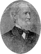
 Thomas H. Canfield
(image printed in the Fargo Souvenir: Christmas 1897, p. 9).
Canfield recommended a more southerly route than originally planned. He recommended going west to Yellowstone rather than north of the Missouri River as planned. Canfield's recommendation was adopted in 1870. It was generally conceded that the point where the railroad crossed the Red River would arise the next great city west of Minneapolis & St. Paul, which each had a population of about 10-15,000 at the time.
Canfield (President of the Lake Superior and Puget Sound Company, a townsite company auxiliary to the Northern Pacific) worked with railroad engineers to select a site for the railroad to cross the Red River. Their work was held in strict secrecy to thwart land speculators.
Early in the spring of 1871, Canfield and George B. Wright traveled to Georgetown on the east bank of the Red River, about 15 miles north of present-day Moorhead. Wright was employed by the Northern Pacific railroad and had been the government surveyor of the lands in northwestern Minnesota.
There was a tradition among the Native Americans (corroborated by Hudson Bay Company employees to Canfield) that the Red River overflowed its banks and the whole Red River Valley became a sea in the spring. Canfield and Wright spent some time that spring going up and down the river searching for high embankments upon which to build a railroad bridge to cross the river. Canfield and Wright decided that Moorhead was the highest point as far as they could determine without instruments.
Meanwhile, a Mr. Linsley, an NP engineer, was examining the countryside. The three met in Mankato and decided that the crossing point would be a few miles south of the 44th parallel of latitude (the present site of Moorhead). Before the crossing point was announced, however, it became necessary to secure where Fargo and Moorhead were to be built.
